Subtitle:
Very early Saturday morning, July 11, 2015, Thomas Bachlechner
and I and two passengers took a sightseeing flight around New York City
to catch some sunrise pictures of the city. We had done a good bit of
planning and things went smoothly.
This will be a combination of a description of the flight, including
the planning and execution, as well as a lot of pictures. So this
resides in my Flying Tales section of my web site. Non-pilots are free
to just look at the pictures and click on the images to see bigger versions.
000-DSC_8070-header: Preparation
000-DSC_8070-headertext:
000-DSC_8070: The plane we used, N53045, a Cessna 172 Skyhawk.
001-DSC_8071: The GoPro camera was mounted on the pilot-side step.
We used the passenger-side door only.
002-DSC_8072: A second GoPro was mounted inside, looking at us.
It would record anything we heard on our headsets (ATC and intercom).
003-DSC_8073: Looking down on the empty camera mount.
004-DSC_8074: And a publicity shot for the East Hill Flying Club.
005-DSC_8075-header: Late, Late Departure
005-DSC_8075-headertext:
005-DSC_8075: Heading east towards the Hudson River, the area was dark
and sparsely populated with only occasional clusers of lights from small
towns.
006-DSC_8076: Cranking up the contrast, a little ground or valley fog
is visible. We knew it wouldn't be a problem, but were aware of it.
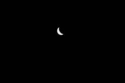
007-DSC_8079: A handheld shot of the cresent moon. It was a pretty dark
night.
008-DSC_8081: Another bit of lights from some small town west of the Hudson.
009-DSC_8083-header: The Hudson River and the Start of the Exclusion Zone
009-DSC_8083-headertext:
009-DSC_8083: Approaching the Hudson around 4am.
010-DSC_8084: Another of the Hudson River at night/early morning.
011-DSC_8086: The Tappan Zee Bridge across the Hudson River.
012-DSC_8089: Having just passed the Hudson, we are descending to
get to around 1100 feet to enter the Hudson Exclusion Zone.
013-DSC_8090: Another just south and west of the Tappan Zee Bridge.
014-DSC_8091: Looking north to the Tappan Zee Bridge on the Hudson River.
015-DSC_8093: Dawn is approaching beyond the Tappan Zee Bridge.
016-DSC_8095: Looking south to George Washington Bridge and the lights of
The City beyond that. The Alpine Tower on the right edge of the picture,
halfway down, marked with red lights, marks the beginning of the
Hudson River Exclusion Zone and is the first mandatory reporting point.
From then on, planes there must fly at or above 1,000 feet and below
1,300 feet. That "tunnel" of airspace is not part of
ATC's airspace (it is "excluded" from their airspace,
hence the name). At 1,300 feet, you are in NY Approach's Class Bravo
airspace without a clearance (that is a very bad thing). Below
that is reserved for helicopters and seaplanes, as well as things like
structures sticking up from the top of bridges.
017-DSC_8098: Heading south towards the George Washington Bridge around 4:15am.
018-DSC_8100: Buildings on the north west side of Manhattan at night.
019-DSC_8102: There are several mandatory reporting points for planes flying
in the exclusion. "GWB" is one of them.
020-DSC_8104: Required position report:
Cessana, GWB, 1100 feet, southbound.
021-DSC_8105-header: City Lights
021-DSC_8105-headertext:
021-DSC_8105: The City at night, with the south end of Central Park visible.
022-DSC_8106:
023-DSC_8107:
024-DSC_8108: Looking east across Manhattan. The LaGuardia airport runway
is visible in the top central area of the picture, just above the water.
025-DSC_8109:
026-DSC_8110: More city lights.
027-DSC_8112: The Empire State Building stands out from the crowd.
028-DSC_8113: The tall building is an apartment building, I believe.
And the one one with the slanting roof is the Citigroup Center (I think).
029-DSC_8114:
030-DSC_8116: More Empire State Building action.
031-DSC_8117: Traffic on the Henry Hudson Parkway.
032-DSC_8118:
033-DSC_8119: Another mandatory reporting point, the USS Intrepid, a
floating navy museum:
Cessana, Intrepid, 1100 feet, southbound.
034-DSC_8120:
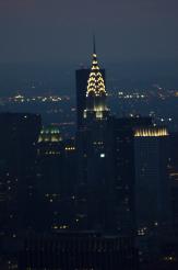
035-DSC_8121: The Chrysler Building
036-DSC_8128: Um, the, um...New York has a lot of big building, you
know? (It's the One World Trade Center Building, and yes, at first
I actually wasn't sure which building it was.)
037-DSC_8130: Looking off to our right, we're just a bit above a
building on the west side of the Hudson, in New Jersey. Remember
what I said about not wanting to fly below 1000 feet?
038-DSC_8136-header: The Statue of Liberty
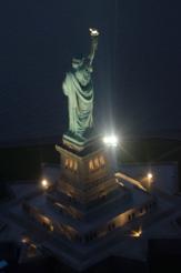
038-DSC_8136-headertext: Once we got to the south end of the Hudson River,
we circled (counter-clockwise) around the Statue of Liberty. Thomas flew
that since he was in the right seat and I had a better view of the Statue.
I took pictures with both of our cameras. Only two of mine were not really
blurry. It was fun to gawk. And of course just like the rest of the trip,
no one was around in the airspace.
038-DSC_8136: The back view of the Statue of Liberty.
039-DSC_8141: The side view of the Statue of Liberty.
040-DSC_8147-header: The East River in the Class Bravo Airspace
040-DSC_8147-headertext:
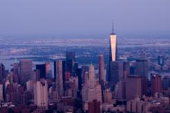
040-DSC_8147: The One World Trade Center Building rising about the NYC
skyline.
041-DSC_8149: South Side Seaport
042-DSC_8152: Colorful sky before sunrise (5:28am, according to my camera)
043-DSC_8155: Midtown Manhattan, including the Empire State Building on the
right side
044-DSC_8158: The west side of Manhattan including the Hudson River
045-DSC_8165: The Tower again
046-DSC_8168: The Chrysler Building and others.
047-DSC_8170: Looking south at the Manhattan Bridge and the Brooklyn Bridge
048-DSC_8174: The tower reflecting light from the rising sun.
049-DSC_8178:
050-DSC_8179: The south part of Manhattan, plus Governors Island. I think the
green patch is Tompkins Square Park in the East Village.
051-DSC_8183: The funky plus-sign-like buildings are part of Stuyvesant Town
052-DSC_8184: More Stuyvesant Town buildings.
053-DSC_8185:
054-DSC_8186: The sun begins to rise (5:31am, for those keeping score at
home).
055-DSC_8193: More sunrise pictures, looking north east, towards LaGuardia.
056-DSC_8195: The UN complex on the bottom left, the Chrysler Building, and a
Trump building.
057-DSC_8199: Central Park
058-DSC_8200: More sunrise action
059-DSC_8201: The south part of Central Park but a super-expensive apartment
building with no name, only an address.
060-DSC_8202: East half of Queensborough Bridge, looking south, from Roosevelt
Island to Manhattan.
061-DSC_8203: South end of Central Park
062-DSC_8204: North end of Central Park
063-DSC_8205: Central Central Park
064-DSC_8208: LaGuardia Airport (we're facing Runway 4/22 and
perpendicular to Runway 13/31)
065-DSC_8213:
066-DSC_8218: NYC has a lot of buildings.
067-DSC_8220: More buildings
068-DSC_8221: More downtown buildings in downtown Manhattan
069-DSC_8224: Second last shot of the Tower at sunrise.
070-DSC_8239: One last shot of the Tower glowing in the light of the rising
sun.
071-DSC_8240-header: Back to the Hudson
071-DSC_8240-headertext: When we decided it was time to leave, we were
at the south end of the East River (I know, that sounds strange). We
asked LaGuardia tower if we could descend out of their airspace, enter
the Hudson exclusion zone and then depart the area to the north. They
approved the request, so we descended back to 1,100 feet, circled around
the south end of Manhattan, and headed up the Hudson River.
After passing the Alpine Tower, we were outside of the perimeter of
the Class Bravo airspace. We called ATC to request radar flight
following to the Cherry Ridge airport, at 4,500'. I was surprised
to hear "Cessna 045, turn on course to November 3-0. Cleared into
the Class Bravo airspace. Maintain 4,500 feet." So we could turn
and re-enter their airspace heading west.
We checked in on the frequency and then for about 5 or 10 minutes
it was pretty busy with them vectoring traffic to and from Newark.
It would be busy, 3 or 4 planes getting vectored one after the other,
then a minute or two of silence on the frequency. We were just north
of Newark. After a bit, we were handed off to the next sector and
then it became quiet again.
071-DSC_8240: The view of the George Washington Bridge from the
Hudson River heading north. It was starting to get a bit hazy but
still descent VFR weather.
072-DSC_8242: Northbound on the Hudson, just passed the GWB. The Alpine
Tower is a little blur on the left side of the river.
073-DSC_8244: Once more, the Tappan Zee bridge, after we talked to ATC
and got a clearance back into the Bravo airspace. We had already turned
left and were heading westbound climbing to 4,500 feet.
074-DSC_8245-header: Onto Cherry Ridge
074-DSC_8245-headertext: Cherry Ridge (N30) is a small airport a bit
northeast of the Wilkes-Barre/Scranton airport (AVP), a little north
but mostly west of Westchester (i.e., the north part of the NYC Bravo
airspace). It took us a little under an hour to get there, flying
over rural Pennsylvania around the 6 o'clock hour.
074-DSC_8245: Lots of trees and grass in the area. All very green looking.
075-DSC_8246: Woods and fields.
076-DSC_8247: There were wisps of low-lying clouds.
077-DSC_8248: More clouds.
078-DSC_8249: Valley fog along the river valley. Outside of that area,
the air was clear. Fortunately, Cherry Ridge is not by a river valley.
079-DSC_8250: Another shot of the low-level clouds from river valley fog.
080-DSC_8251-header: Breakfast at Cherry Ridge
080-DSC_8251-headertext: We had breakfast at the
Cherry Ridge Restaurant
at the Cherry Ridge Airport near the Scranton/Wilkes-Barre area. We arrived
at 7am, but the restaurant wasn't supposed to open until 8am. We
noticed a sign said "open" and the doors were unlocked. We
went in and asked. The owner, Marty, said, "well, I'm here, and
you're here, so lets do it."
It's a nice restaurant, the food was good, the people were friendly,
and we sat on the deck watching as (eventually) other planes came and went.
The owner used to run the restaurant at the Sky Manor airport in New
Jersey (N40). The Cherry Ridge airport (N30) restaurant has changed
hands a few times in recent years. Hopefully, now they'll last.
It's worth a visit.
080-DSC_8251: Thomas, Juana, and Adam after we landed.
081-DSC_8252: Thomas takin ga picture of me, taking a picture of him, with
Juana in the background.
082-DSC_8253: Adam and Juana after breakfast waiting for us to go.
083-DSC_8254: Adam and our Skyhawk. (It was his 30th birthday!)
084-DSC_8255: Juana and Adam, our trusty passengers.