
I flew to Martha's Vineyard on Wednesday, September 19, 2012. I had been watching the weather all week, and a storm system had just blown through. The weather was already east of Nantucket before I left, and the flight out was pretty and uneventful. I flew IFR at 5000 feet, more or less heading due east. Simple.
I spent a few days there, it was beautiful, sunny, and generally warm. A very pleasant trip.
I planned to leave for the return trip on Saturday morning, September 22, 2012. But the forecasts were showing potential problems as a cold front would be moving through Ithaca, heading east, although east of the Hudson River the weather was forecast to be quite nice.
A few other factors to add to the mix:
Of course the weather wasn't exactly as forecast and it required some aviation decision making aloft. The flight pushed my comfort zone envelope (and it feels like the envelope pushed back), but in the end I think I conducted the flight safety and I made it home. Oh, and the track of my flight, combined with the radar, comes from FlightAware.com which is a great site for this sort of information.
Just looking at the flight track with the radar image overlaid, it looks like a really stupid thing to do and that I crossed right through a line of level 3 storms. However, that's not exactly what happened, and the picture shows the radar track across the 3+ hours of the flight. It was actually distinct cells, moving northeast in a diagonal line, many just "level 1" radar echoes, with some space between them.
So now let me dig into the details.
So the first half of the trip should be fine, but I really could not figure out the second half of the trip ahead of time. So I decided it might be best to break it up into two segments. First, fly about halfway, near Kingston or Poughkeepsie, by the Hudson. I could even do that VFR, which means I could just fly due west. Generally, there's always odd IFR routing heading west from Martha's Vineyard. I'd get flight following, but then I could turn it into an IFR flight and go the rest of the way. And if I left by 10am, I could get in before the storms (and the front) were supposed to pass through the area. Seemed reasonable and allows for some flexibility.
Bad weather.
Already at the destination.
It was no longer a theoretical question of "what if there was bad weather at the destination?" it was already there. The plan had to be modified to accommodate a go/no-go decision.
Well, that'd put me around halfway there. It's a shorter trip home from Duchess County (Poughkeepsie) than from Martha's Vineyard. My sister lives about an hour away from there. And I have two friends who live in Albany. So I'd have places to spend the night in a pinch. However, given that if I did spend the night somewhere else, I'd probably want to leave early on Sunday morning to try to get back to Ithaca by 8 or 9am, so the plane could be used for rides for the flying club's pancake breakfast. That meant I'd be sleeping in the pilot's lounge at an FBO. I've done that before. I noticed there were two FBOs at POU, and one advertised they were going to have an all new, remodeled pilot lounge. OK, I could stay there. Probably borrow a car to get dinner.
It seemed like it would be worth it to get closer. I could see if the weather had blown through Ithaca or not. I could make the continue/stop decision (a variation on the go/no-go decision). I called up Flight Service to get a weather briefing and file a flight plan.
The weather was starting to look better. I grabbed a quick lunch (leftover lobster roll...yum!) and went to the airport.
Also note that it was very deliberate that I filed Poughkeepsie as the destination. That was as far as I was committing to flying. If I wanted to press on, I wanted it to take active intervention on my part, as opposed to filing for Ithaca and then taking an active intervention to not go home. The goal was to put me in the mindset that I had very much not committed to going any further than POU.
I called and got the clearance. I was surprised by the clearance. It was nothing like going along the southern part of the coast. Instead, it looked like this:

The route was runway heading, then radar vectors, then direct to Providence (PVD) which is the first dot along the lines in the middle of the two concentric circles, then northwest to the Putnam (PUT) VOR, which is the northernmost point on the course, then direct to the "BLATT" intersection to the southwest, then back down to the "NELIE" intersection, which is by the Bradley International airport (another double circle) then over the "TRESA" intersection (I had to ask for them to spell that one), and then south, direct to Poughkeepsie. Climb and maintain 2000 feet, expect 6000 feet 10 minutes after departure.
To further complicate things, I was using my handheld radio to get the clearance, and the batteries were low, so the controller could not hear me when I finally read back the proper spelling of TRESA. I quickly turned on the plane's radio, tuned in the clearance frequency, and read back the proper clearance and got the familiar "readback correct" confirmation.
Having written down the clearance, the next step was to find out where the hell they were sending me. Fortunately, it was a mostly a matter of simply typing it into the iPad and checking it out. The IFR chart is less crowded and generally only has airway and airport information, as opposed to every lake, highway, and hill that the VFR charts do. Here's what the route looks like on the IFR chart:
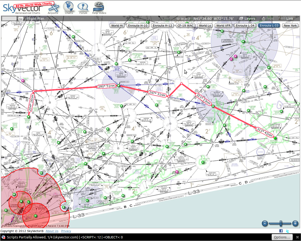
The routing, while a little odd with the dog-leg up to Putnam and then back down, wasn't that out of the way and mostly followed a published airway or two. The 6000 foot altitude was a minor annoyance but didn't really matter. Besides, given that the field was IFR, I had little choice beyond "take it or leave it." So I took it.
I applied takeoff power and was off the ground before the intersecting runway. Climbing out, I could see that the clouds were scattered to broken. It wasn't bad, but still. Tower handed me off to Cape Approach who immediately cleared me to 6000 feet. As I climbed, I could say a bit off in the distance was a pretty solid cloud deck. And checking Poughkeepsie's current weather, they had a 3000 foot overcast layer. If I wanted to fly above things, and I did for the moment, I'd need an instrument clearance to get back down through the clouds to land at Poughkeepsie. The idea of staying on my IFR clearance started to seem like a better idea, and BLATT and Nelie and Putnam remain as my destinations. Fine.
In reality, ATC was very cooperative. Cape Approach handed me off to Providence Approach. As I got a little closer to PVD, I called up and requested direct BLATT. After a short pause, the controller came back and cleared me direct to BLATT. No odd dog-leg. I figured the pause was because BLATT was in another controller's sector. And shortly before reaching BLATT, Providence Approach handed me off to Bradley Approach. Without my asking, the controller cleared me to TRESA. So I went south of Providence, avoided Putnam altogether and would be skirting south of Bradley. All in all not too bad.
There are not many options for places to land between those two points in case things take a turn for the worse. I could always turn around and head back east, but that would be an option I'd rather avoid. Oneota and Sydney were possible stopping points. More for waiting out a storm for a half hour rather than a luxurious place to spend the night. But at least there were some options.
The more I looked at the radar track, the more I felt that it should be possible to avoid the worst of the weather. Plus, these appeared to be rain storms, not thunderstorms, like I had seen earlier in the day.
I considered calling Flight Service, but it seemed like they would be giving me the same data that I had (radar, forecasts, and current conditions). Actually, they could provide pilot reports, area forecasts, cloud tops and more. Perhaps I wasn't even sure how I'd ask them or what I'd ask them. In retrospect, it probably would have been worth it to get as much information as I could, and then decide what I should pay attention to.
No matter. I made my decision and keyed the mic.
"Bradley Approach, Cessna 045 would like to change our
destination to Ithaca, India Tango Hotel."
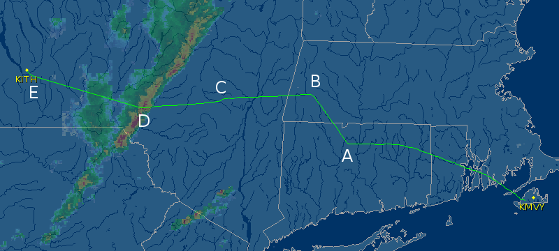
The controller came back and gave me a vector, heading 330 (northwest) and said he'd have the new routing in a moment. Then he came back with the new clearance: direct STELA intersection, V270 airway, CFB (Binghamton VOR), direct Ithaca. Here's the radar track of my course, with some labels.
Bradley passed me to Albany. And after a bit, Albany called and
said, "Cessna 045, climb and maintain 8000." Perhaps
it was because it (seemed) like an out of the blue altitude change
or maybe there was some disappointment in my voice when I read the
new altitude back, but the controller replied without me asking, saying
the change was because the minimum enroute altitude for this segment
of the airway was above 6000 feet (6300 feet getting close to De Lancey,
so the nearlest even thousand foot altitude is indeed 8000 feet).
I climbed to 8000. That kept me above most of the clouds. It was blue sky above.
Albany passed me off to Boston Center. After a bit, they called and asked if I was on the airway to De Lancey. I said I was on the airway to Binghamton. A few minutes later, the controller called and said she was showing me 10 degrees right of course. The GPS showed I was on course. I said I'd correct, turned to the left a bit, and then took a closer look at the chart. The V270 airway goes to the De Lancey VOR and then the Binghamton VOR. It's not exactly the straight line, as De Lancey is a little bit south of the direct line between STELA and Binghamton. My mistake. Fortunately, it's easy to add or remove waypoints from the flight plan in the GPS (I do like the Garmin 430/530 user interface). Point C on the track picture shows the small shift to the south.
I was heading towards De Lancy. And watching the iPad. Once I stopped fiddling with it and just let it update on its own, not make it scroll and zoom in and zoom out, the hemorrhaging of the battery power ceased. The controller said that there was a cell ahead of me but it looked like my current route would avoid it. I heard her calling out to other planes, like United, that there was "extreme" precipitation by Rockdale, which was 20 miles to the north. She then passed me over to Binghamton.
Sometimes there are lines of storms in which the entire line moves (typically eastward) and looks like what was shown on the radar. There'd be no way to get through or above them, and going around would take a lot of time and fuel. In that case I would land and wait for the line of storms to pass by. If there's nothing immediately behind it, it might mean stopping for lunch for an hour while it rains, and then continuing onward. Other times it means stopping for the day.
In this case, there were small cells of storms, just one or two that were moving away from Ithaca and there was a lot of space around them. None of them were showing convective activity (i.e., thunderstorms) and it seemed reasonable that there would be space to navigate around them. They were showing red in the center, along with yellow, and green, meaning there was a lot of rain in the clouds. Even if it's not a thunderstorm, a level 3 radar return would not be something to fly through.
The radar images I had from the satellite downlink were anywhere from 5-15 minutes old, and maybe even older. From 100 miles out, I could look at the nature of the weather and make decisions of whether it looked like it would be possible to get around them or not (strategic go/no-go decisions). I would not use the images for navigating around the cells, since they are moving, maybe at 20-30 knots, which means after 15 minutes, they are several miles away from where they are portrayed on the image. Only live radar can be used for such tactical decisions, the type that well equiped planes (like commercial jets) have. But ATC also has that kind of radar.
At this point, there was a large cell, just to the north (right) of me, and then a bit behind it and to the south was a second one. At this point Ithaca was clear of weather. The trick would be getting by those two cells. The controller asked if I'd like vectors around the weather.
Affirmative.
I guess that was something else I had counted on. BGM wouldn't be very busy and they are usually helpful, and they do have radar. Still, it's relying on someone else. Sometimes it's necessary, but best to go in to things understanding that.
He gave me a 330 vector. According to the iPad, that would put me right into the cell. My guess is that the iPad's weather was a few minutes old, while the controler's radar was live. And he was steering me close to the cell, but still on the backside of it, so I could get around the one in front. I made the turn. These vectors are shown as point D on the track graphic, but all the turns are not shown.
I entered the clouds. There was some light bumping around. I kept the wings level. A little precipitation, but nothing too bad. Then I noticed I was climbing. Fairly fast. Updraft. What was maneuvering speed? Around 92 knots. Maybe I should throttle back just a little. Shit, I'm at 8500 feet. I will need to pull back the...
And then it hit. Or perhaps I hit it. All it was was a single bump.
A single, very violent bump. It would be described as "severe turbulence" and was probably the worst bump I've hit in my almost 1000 hours of flying. Everything jumped. Everything made a noise—the noise of solid things hitting each other. I saw something (some things?) fly off the top of the panel, near the windscreen. Was that my checklist? Would I need it later? My head hit the ceiling of the cockpit; fortunately my headset is padded, so I was fine. I immediately throttled back and no longer cared about my altitude. Just keep wings level, don't stress the plane, and fly through this area as quick as I can.
The controller gave me a turn to the left, and I did. After another minute, the controller called and said there was some "moderate precip" up ahead. A few seconds later, he asked if I wanted vectors around them. Again, yes please ("affirmative"). I should have asked him, but I was a bit preoccupied. The jolt had certainly startled me, but I really wasn't scared. I hoped there wouldn't be more following it, but at this point I was trusting that the controller was routing me to avoid the worst of the weather and that the weather would be passable. I called up and gave him a PIREP (pilot report). Other than the solitary bump, the ride was smooth and the precip was light.
I flew through some rain and then after another minute or two exited the cloud. The controller cleared me to go direct Ithaca and I did. He also said to let him know if I needed to change altitudes. After a bit, I looked at the ground speed indication from the GPS. My groundspeed was 65 knots! I requested a descent to 6000 feet, and received it. At this point I was around 30 miles east of Ithaca. Approaching 6000 feet, I requested 4000 and received it.
There were scattered and broken clouds in the area. I could make out some occasional landmarks and the ceiling was reported as 2000 or better, so it wouldn't be a low approach by any means, but I took the vectors to the ILS. Point E on the track graphic shows where I got a vector to turn me on to the final approach. Then I intercepted the glideslope (vertical guidance). Very shortly after intercepting the glideslope, I spotted the airport. I continued the approach on down, just to practice tracking, although I was looking out on occasion to see the airport and look for traffic. Though not my best landing, I arrived without incident and taxied in.
It feels like for the most part, I had "outs." I was evaluating the weather along the way, trying to make reasonable decisions about whether to continue or not. I would not have wanted to fly through the worst of the cells, but the vectors around them kept the ride pretty smooth (with the single exception of The Bump). Had ATC not been able to provide vectors, I would have needed to change the plan. I probably should have taken positive action and asked Binghamton approach early on, just to make sure. And it might not have been a bad idea to talk to Flight Service. Also, I should have tried to get some paper charts as a backup (I had VFR charts) in case there were iPad problems.
I think most of the changes are fine tuning and thing the flight was conducted safely.
As is often the case with pushing one's limits, it was a learning experience.